
Colorado Topographical Map
Static Colorado Topo Map
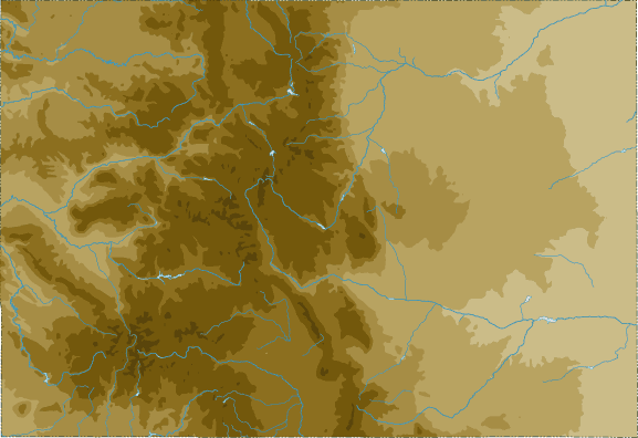
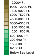
This section features a topographical map of Colorado as well as a map legend that specifies elevation ranges and indicates their corresponding map colors.
Map Legend |
 |
|
 |
Colorado Topographical Features
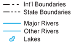
Colorado's highest mountain is Mount Elbert, whose peak is 14,431 feet above sea level. Other notable mountains in Colorado include Blanca Peak (14,317 feet), Longs Peak (14,255 feet), and Pikes Peak (14,110 feet). Colorado's lowest elevation is 3,350 feet above sea level, at the Arkansas River. Colorado landforms include the high plains in the eastern half of the state and Rocky Mountains in the western half. Major rivers in Colorado include the Colorado, Arkansas, South Platte, and Rio Grande.Interactive Colorado Topo Map
This section features a topographical map that can be zoomed and panned to show the entire State of Colorado or a small portion of the state. To zoom in or out on the map, use the plus (+) button or the minus (-) button, respectively. To pan the map in any direction, simply swipe it or drag it in that direction. At high zoom levels, the contour lines on this Colorado map can help outdoorsmen, land developers, and others to plan their routes and activities more efficiently.
Copyright © 2005-2024 State-Maps.org. All rights reserved.
Colorado-Map.org is a State Maps reference source.
Colorado-Map.org is a State Maps reference source.